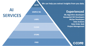
Secure Cloud Storage, Cataloging, Cloud Native Conversions
Cost effectively store, and find your geospatial data

Calibrate, Extract Insights, Label
Algorithm Development, Processing Chain Automation including MLOps

Web, Mobile, PWA, API
We can help you get your data into the hands of your customers or existing toolsets.

Sherlock is a Cloud Native, Open standards search engine for geospatial data. It 1) converts data into standard formats, Cloud optimized GeoTIFFS (COG) for rasters(satellite imagery, drone data), and GeoJSON for vectors 2) Catalogs data in STAC 1.0 as well as a web performant elastic search index, and 3) displays data in a simple to use modern web based search interface.
C-CORE’s satellite-based river ice monitoring service delivers information about the extent and condition of river ice to decision-makers in near real time. C-CORE analyzes synthetic aperture radar (SAR) imagery from many sources, as well other ice thickness monitoring tools such as ground penetrating radar, ice thickness buoys, weather data and other ancillary data. Check it out for yourself on one of the top 20 river systems on the planet in the link above.
Coresight SMS leverages the Coresight infrastructure to provide satellite monitoring solutions for Pipelines, Oil & Gas, Civil Infrastructure and Environmental use cases. These services leverage optical, synthetic aperture radar, and other EO sensors to provide situational and temporal analysis providing actionable insights. Click on link to learn more on our looknorthservices.com website.
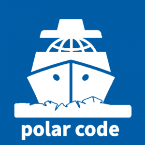
This project has built a Polar Code software application that combines Synthetic Aperture Radar data (ESA Sentinel-1 data) of Arctic sea ice with vector-based eastern Arctic sea ice products from Canadian Ice Service, creating a Polar Code compliance and decision support tool for Ships Navigating in Polar Regions.
C-CORE has been monitoring the oceans for years. Our surveillance services help governments and industry monitor icebergs and vessels to ensure safety of human lives,as well as protecting the environment, and guarding against illegal activities. C-CORE is working with IDG to build a fully integrated end-to-end maritime survelliance solution – learn more at idg.network.
C-CORE’s Floe Edge Monitoring Service provides near real-time sea ice imagery and information to Canadian arctic communities using an online delivery system. The purpose of the service is for safe navigation both on and off the ice. The service allows users to access remotely sensed data in the form of optical and RADAR satellite imagery in a timely manner.

C-CORE leverages Coresight to download and convert the Canadian Ice Services Regional Ice Concentration charts into geospatial cloud native formats. These products can be accessed via the floe-edge website, or alternately via our C-STAC ( C-CORE STAC) API. For more information click the link above.

Enhancing Satellite-based Remote Sensing Northern services by enabling Arctic community-based Drone operators to contribute high resolution time sensitive data to boost these services. Project funded by European Space Agency.
C-CORE has extensive experience developing Machine learning algorithms to extract insight from Earth Observation data such as change detection, object detection (oil spills), and object classification (land, ship/icebergs, and ice classifications). C-CORE in partnership with Equinor ran one of the largest image classification contest on the internet using the Google owned Kaggle platform. The machine learning competition generated over 40,000 entries from over 3000 of the worlds best data scientists. The success of this project was based on well curated/labeled data and underlying research to providing new to EO data scientist a running start.